The region of South Street Seaport, NY, otherwise known as Lenapehoking, is the Indigenous territory of the Canarsee and Manahatoos, who once cultivated and protected the lands we now assemble on at the South Street Seaport Museum.
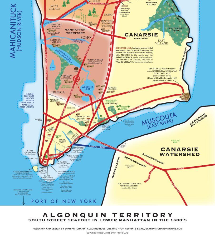
Whereas the South Street Seaport Museum acknowledges that the South Street Seaport site has been a landing place for thousands of years, and the Canarsie, a sea-going people, stewarded both sides of the East River, crossing it daily, thus the name Canarsie, “Keepers of the Watershed.” Fulton Street in Brooklyn follows an indigenous trade route to the Atlantic, and Fulton Street in Manhattan continues the route across the Hudson (Mohicanituck), where it becomes Communipaw, NJ (“Landing Place on the Other Side”). Current-day Maiden Lane was a street/gully that gave mariners easy access to the ridge trails of the island; the shoreline two blocks to the north and south of its mouth were prime landing locations. The north end lined up with the Long Island Trail, now known as Fulton Street, to bring native trade items from far away to the isolated people of Long Island, who had limited access. This later blossomed into Fulton Market. Today’s South Street Seaport is still located right between Fulton Street and Maiden Lane.
Whereas the South Street Seaport Museum recognizes that what is now Fulton and Water Streets, part of the old “Fulton Landing,” is built on the western landing of the traditional ferry crossing across the East River, which is not a river but a tidal strait called Muscoota by its indigenous inhabitants (or Place of Reeds).
Whereas this acknowledgement remembers the tribal groups that once lived within a mile of this spot, including: the Ramapough, the Manahatta Munsee (west of Lafayette Street), the Canarsie, the Werpoes, and the Kapsee. The Mohicans, who would travel to Manahatta along what is now Route 9, famously called “the Mohican Trail,” which includes all of Broadway, were ancient residents and later, frequent visitors here. Moreover, we honor the presence of the Wappingers, including the Rechewanis, Rechawawank, and Rechtank.
Now, therefore, be it resolved that the South Street Seaport Museum graciously accepts this land and water acknowledgement to establish and maintain good relations with our indigenous neighbors by honoring the inhabitants of the land prior to 1600. We pronounce this as a declared effort to inform, educate, and demonstrate our commitments as advocates of inclusion.
Dedicated on November 19, 2023, by
Dwaine Perry: Sachem/Maqua/Chief, Ramapo-Munsee Nation in Lenapehoking
Oleana Whispering Dove (Enrolled Ramapo-Munsee); Keeper of Cultural Lifeways
Jonathan Boulware, South Street Seaport Museum President
Zak Risinger, Acknowledgement Coordinator
Brief Indigenous Seaport History

This history is included in the South Street Seaport Museum Land Acknowledgement dedicated by Dwaine Perry, Chief of the Ramapo-Munsee Nation, and Oleana Whispering Dove (Enrolled Ramapo/Tsalagi Descendant) Keeper of Cultural Lifeways for the Ramapo-Munsee Nation.
Map and history from Mapping Manahatouac: Land Acknowledgements for Manhattan, Long Island, Connecticut, Rhode Island, Northern New Jersey and Downstate New York, by Evan Pritchard (Mi’kmaq Descendant); Executive Director, Center for Algonquin Culture.
Although natives used tributaries as central highways through the middle of town, they were obligated to use the same rivers as boundaries with colonial land speculators, thus upsetting their own sense of relationship to the land. All headwaters were considered sacred-places where warfare were banned. Rivers and streams were the main forms of transportation. Canoers would take full advantage of the tides to conserve the (muscle and caloric) energy of the day.
An effective energy conserving practice was to hoist the canoe and all their gear over their heads and walk from one river to the other on foot along certain trails. Those trails were special portage trails and many are still in existence today. In one or two hours of “carrying it” a team of canoers could eliminate up to 10 hours of paddling. Americas Native-worn portages were discovered by the French, hence the name.
One of the characteristics that unites this lower Manahatouac region in terms of trade and cuisine was and still is the delectable oyster. It is said that on September 12th and 13th, 1609, when Henry Hudson first tasted his first very good local oysters the region had 350 miles of oyster reefs and over half the worlds population of oysters, could be found in Manahatouac.

